Category: Press release
-

Accurate road surface data for transportation, safety, and economic development
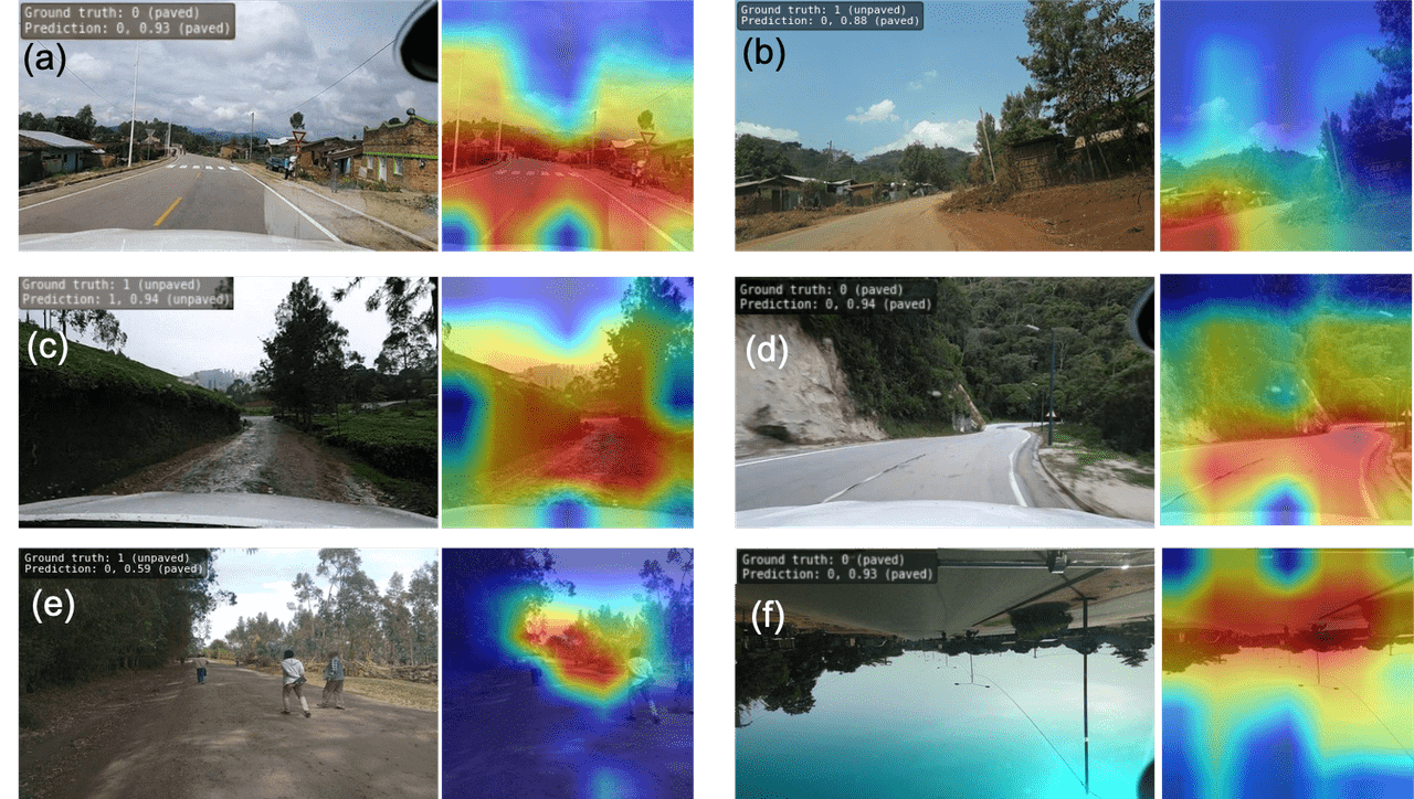
Researchers at HeiGIT (Heidelberg Institute for Geoinformation Technology) have publicly released a first of its kind planet-scale dataset on road surface type (paved or unpaved) using state-of-the-art GeoAI methods based on street-view imagery from Mapillary, in order to support humanitarian response, urban planning and progress towards the Sustainable Development Goals. Road surface information plays an essential…
-

DFG Software Grant
Successful proposal: Fostering a community-driven and sustainable HELIOS++ scientific software The 3DGeo Group and the Scientific Software Center (SSC) of Heidelberg University have been successful with their proposal in the DFG call “Research Software – Quality assured and re-usable”, together with two other project proposals at Heidelberg University (see press release). The main objective of…
-
New(s) story about Sensing Mountains Summer School 2022
The fourth edition of the Innsbruck Summer School of Alpine Research took place in September 2022, finally back in the lovely mountain landscape of the Ötztal valley in Tyrol, Austria. Once again, 40 participants – young researchers from all over the world – gathered in Obergurgl to learn and exchange about new concepts and solutions…
-
Danziger Scholarship Applications Extended to Aug. 31
Do you know an African student hoping to do a PhD in GIScience at the University of Heidelberg? The Robert and Christine Danziger Scholarship deadline has been extended to August 31. Up-and-coming doctoral students from Africa, especially Ghana and West and Central Africa, are invited to apply for financial support. Applicants can apply for a…
-
Audiobeitrag: Das Heidelberg Institute for Geoinformation Technology (HeiGIT) im Campus Radio
Damit Geoinformationen sicher und einfach genutzt werden können und Hilfsorganisationen bei Katastrophen bessere Orientierung haben, gibt es das HeiGIT. Unterwegs in einer fremden Stadt? Kein Problem, jedes normale Smartphone hat heute eine Satellitenverbindung. Die Routenplanung wird dabei immer besser. Dank Geoinformationen finden Rollstuhlfahrer heute niedrige Bordsteine und Hilfsorganisationen Rettungswege nach einer Katastrophe. Damit solche Daten…
-
HGG Vortrag: Heute: Erneuerbare Energien als Entwicklungschance? Deutschland und Kenia im Vergleich. Prof. Klage, 17.05., 19:15 Uhr
Hiermit möchte wir Sie herzlich zum HGG Vortrag von Prof. Dr. Britta Klagge (Universität Bonn) zum Thema “Erneuerbare Energien als Entwicklungschance? Deutschland und Kenia im Vergleich” einladen. Der Vortrag findet am Dienstag (17.05.2022) um 19:15 Uhr im kleinen Hörsaal des KIPs (INF 227) der Universität Heidelberg statt. hgg.urz.uni-heidelberg.de Der zunehmende Einsatz erneuerbarer Energien geht mit…
-
New “Robert and Christine Danziger PhD Scholarships“ 2022 in Geoinformatics at GIScience Heidelberg University for PhD students from Africa – DL 15.July
It is our great pleasure to inform about the new “Robert and Christine Danziger Scholarships“ 2022 for doing a PhD in Geoinformatics at Heidelberg University. Please make yourself familiar with the research topics at GIScience Heidelberg and HeiGIT (e.g. projects, papers) when suggesting potential topics for your PhD research. Short facts: The Robert and Christine Danziger Scholarship is awarded to very…
-
Räumliche Daten für die Gesellschaft – HeiGIT in die Zukunft geführt
Unterführungen, Treppen und hohe Bordsteinkanten sind für Menschen mit Gehbeeinträchtigungen eine große Herausforderung. Ein maßgeschneiderter Routenplaner kann aber ihre Mobilität erhöhen, indem er Wege mit möglichst wenigen Hindernissen berechnet. Dieses Beispiel zeigt, wie Geoinformationstechnologie und Geoinformatik speziellen Gruppen in der Gesellschaft ganz konkret helfen. HeiGIT, das Heidelberg Institute for Geoinformation Technology, entwickelt nicht nur passgenaue…
-
United Nations World Data Forum Blog on Healthcare Accessibility Map
In the context of the United Nations World Data Forum 2021 organised by the United Nations Statistics Division and UN member states a series of blogposts has been published by UNSTATS. Among them is one by Alexander Zipf about improving access to healthcare facilities through geoinformation and crowdsourcing. He introduces the Open Healthcare Access Map…
-
WENN ES IN DER STADT ZU HEISS WIRD
Aktuelle Meldung der Universität Heidelberg zum Projekt HEAL: https://www.uni-heidelberg.de/de/newsroom/wenn-es-in-der-stadt-zu-heiss-wird BADEN-WÜRTTEMBERG STIFTUNG FÖRDERT HEIDELBERGER PROJEKT ZU ROUTINGDIENST MIT HITZEVERMEIDENDEN WEGSTRECKEN Wo in der Stadt Heidelberg ist es besonders heiß und wie wirken sich lokale Hitzebelastungen auf gefährdete Personengruppen aus? Mit dieser Frage befasst sich ein Forschungsprojekt, durchgeführt von der Abteilung Geoinformatik und dem TdLab Geographie am Geographischen…
-
MapSwipe is App of the Day in Apple AppStore
MapSwipe has ben announced as ‘App of the Day‘ in the Apple AppStore! (27.08.2021) Thank you to all our volunteers for the continued help and support which keeps the app going. Read the blogpost here: https://apps.apple.com/ca/story/id1559236909 The team at the Heidelberg Institute for Geoinformation Technology (HeiGIT) and the GIScience Research Group at Heidelberg University has shaped MapSwipe’s…


