

Author: Maya Moritz
-
HeiGIT and GIScience at AGILE 2023
Earlier this month, the Association of Geographic Information Laboratories in Europe (AGILE) held its 2023 conference, and GIScience and HeiGIT team members contributed presentations, analyses and papers toward this year’s theme of “Spatial data for design.” At the conference’s host university Delft University of Technology (TU Delft) in the Netherlands, the team members contributed work uniting design…
-
Mosquito App Alert
Prof. Dr. Alexander Zipf and Charlie Hatfield from HeiGIT contribute with their expertise on participatory science to an interdisciplinary case study by IDAlert on the monitoring of invasive mosquito populations in Heidelberg and the Rhine-Neckar-Region. One part of the case study is the Mosquito Alert App that recently has been launched in Germany and draws…
-
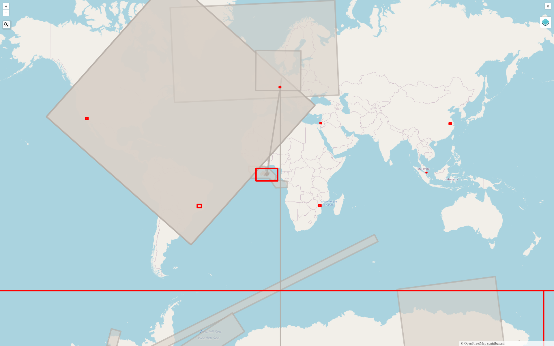
2022 #30DayMapChallenge Round-Up Part 2: Deleted Maps
Featured photo: The deleted map displays all deleted elements within the analyzed areas (red). Gray rectangles represent deleted buildings. This past November, our teams at HeiGIT and GIScience participated in Topi Tjukanov’s Twitter event #30DayMapChallenge, where mappers display their creativity and ingenuity with a set of 30 daily prompts ranging from colors to specific datasets…
-
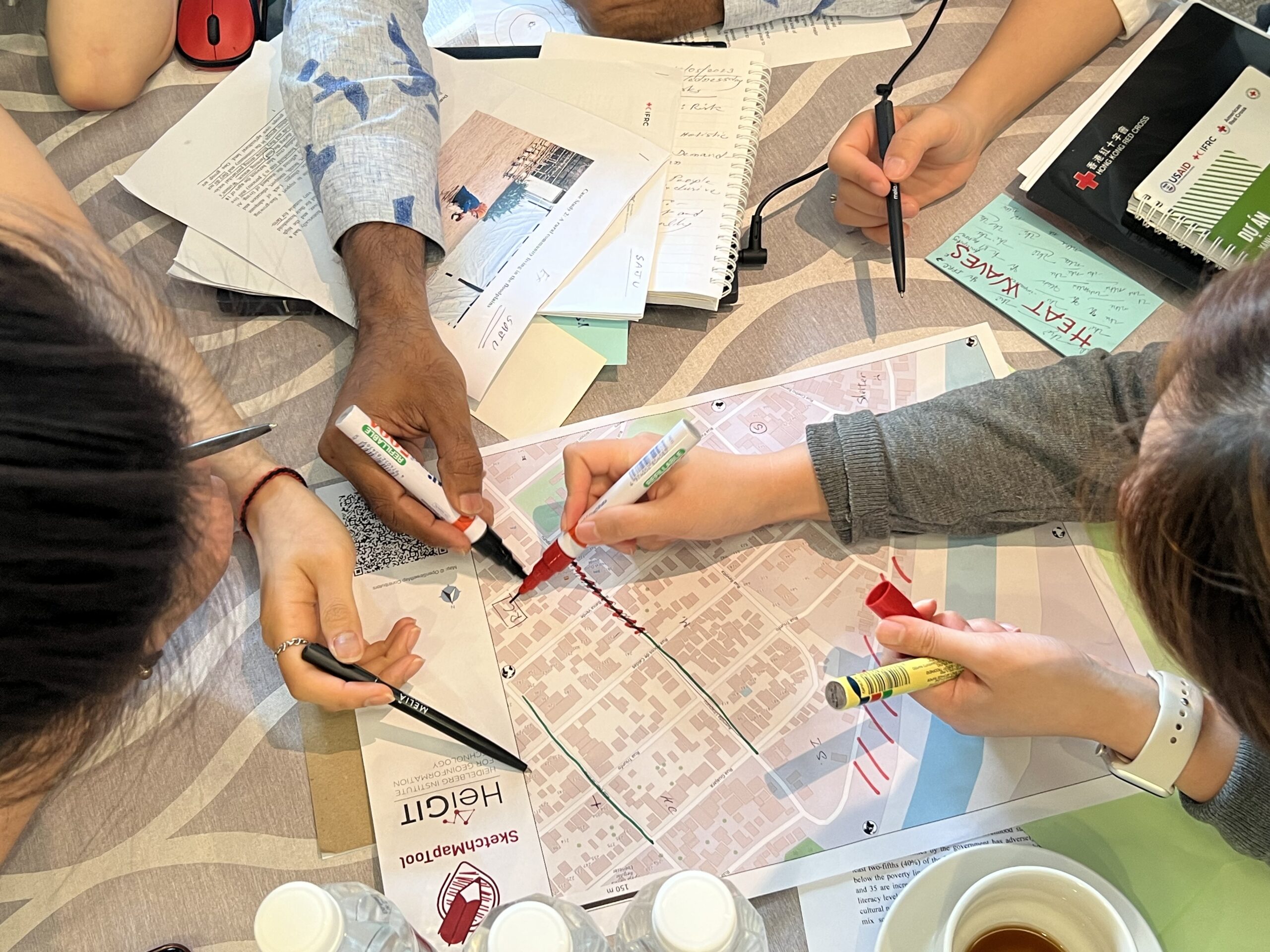
Training on digitalization of participatory mapping in Kuala Lumpur
Featured Image: Training participants simulating a participatory mapping on the ground with the SketchMapTool. Last week, HeiGIT team member Anne Schauß held a workshop session in Kuala Lumpur, Malaysia, during a training of the International Federation of Red Cross and Red Crescent Societies (IFRC). The international training focused on community resilience and how to assess…
-
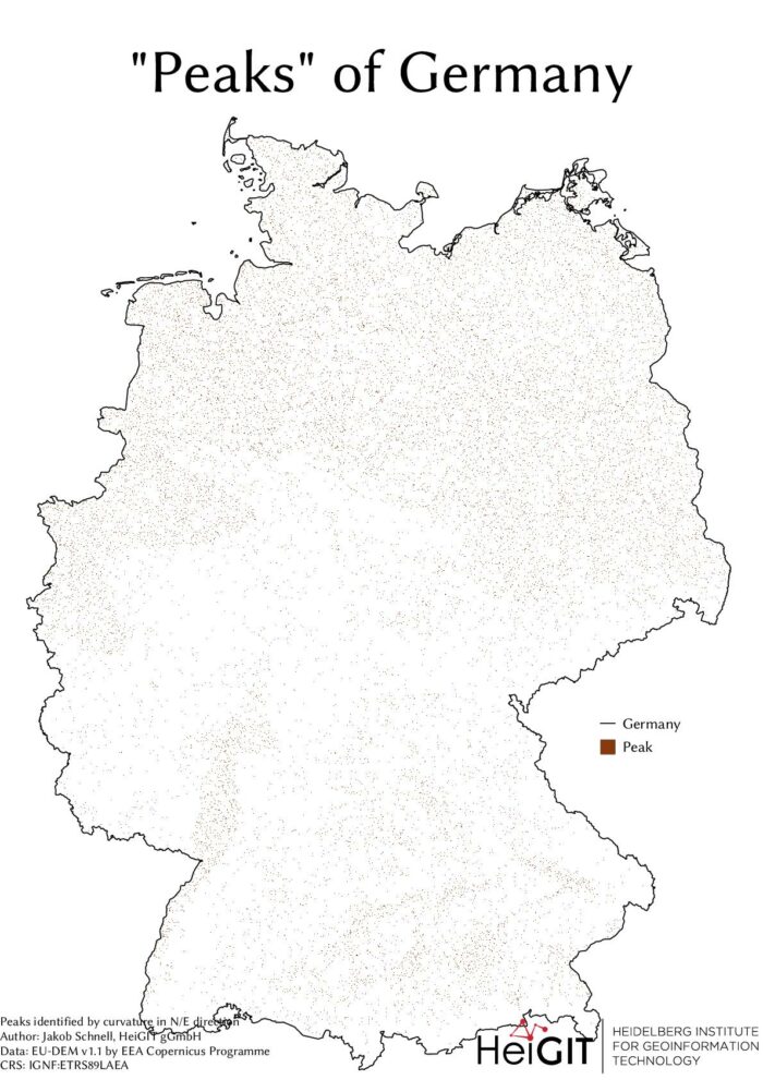
#30DayMapChallenge Round-Up Part 1: Germany Three Ways
Featured Image: The peaks of Germany identified by curvature in N/E direction, Jakob Schnell’s contribution for Day 7 (Raster) of the #30DayMapChallenge. This past November, our teams at HeiGIT and GIScience participated in Topi Tjukanov’s Twitter event #30DayMapChallenge, where mappers display their creativity and ingenuity with a set of 30 daily prompts ranging from colors to…
-
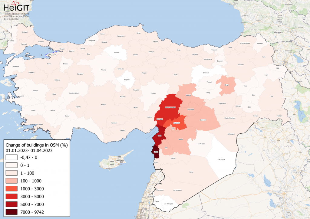
How to become ohsome part 15- Analysing Changes in OSM after the Earthquake in Syria and Türkiye in February 2023
Featured Map: Percent change in each province of Türkiye and Syria of buildings in OSM. Data from OpenStreetMap, visualized using QGIS and the ohsome API plugin. Welcome back to the how to become ohsome series! If you’re new to the series, you can check out the previous issues (like this one) or the ohsome Region of…
-
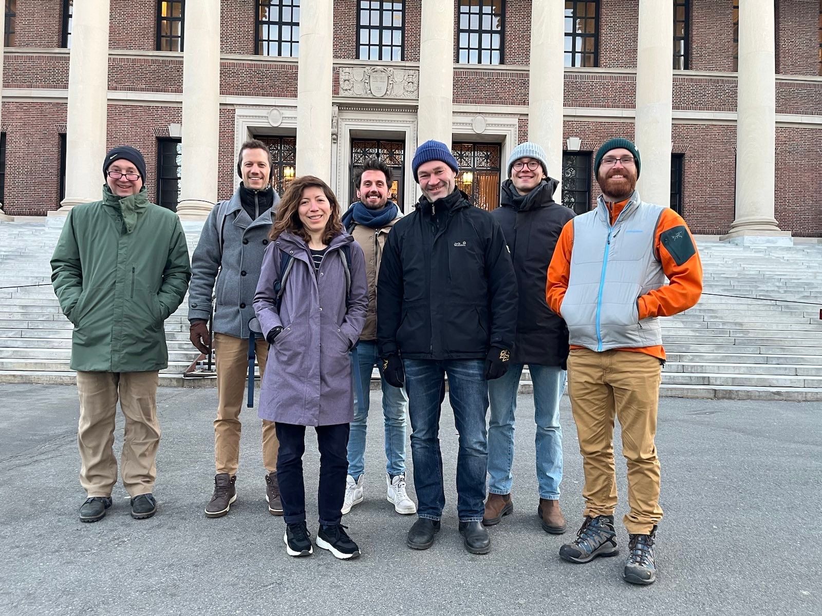
GeoEpi at CGA 2023: From Geospatial Research to Health Solutions
Featured photo: The geoEpi team attending CGA 2023. Back row from left: PD Dr. med. Thomas Jaenisch, Assoz. Prof. Dr. Bernd Resch, Dorian Arifi and Steffen Knoblauch. Front row from left: Dr. rer. nat. Ivonne Morales Benavides, Apl. Prof. Dr. Sven Lautenbach, and Dr. Yannik Roell. Ever since Dr. John Snow’s 1854 tracing of a…
-
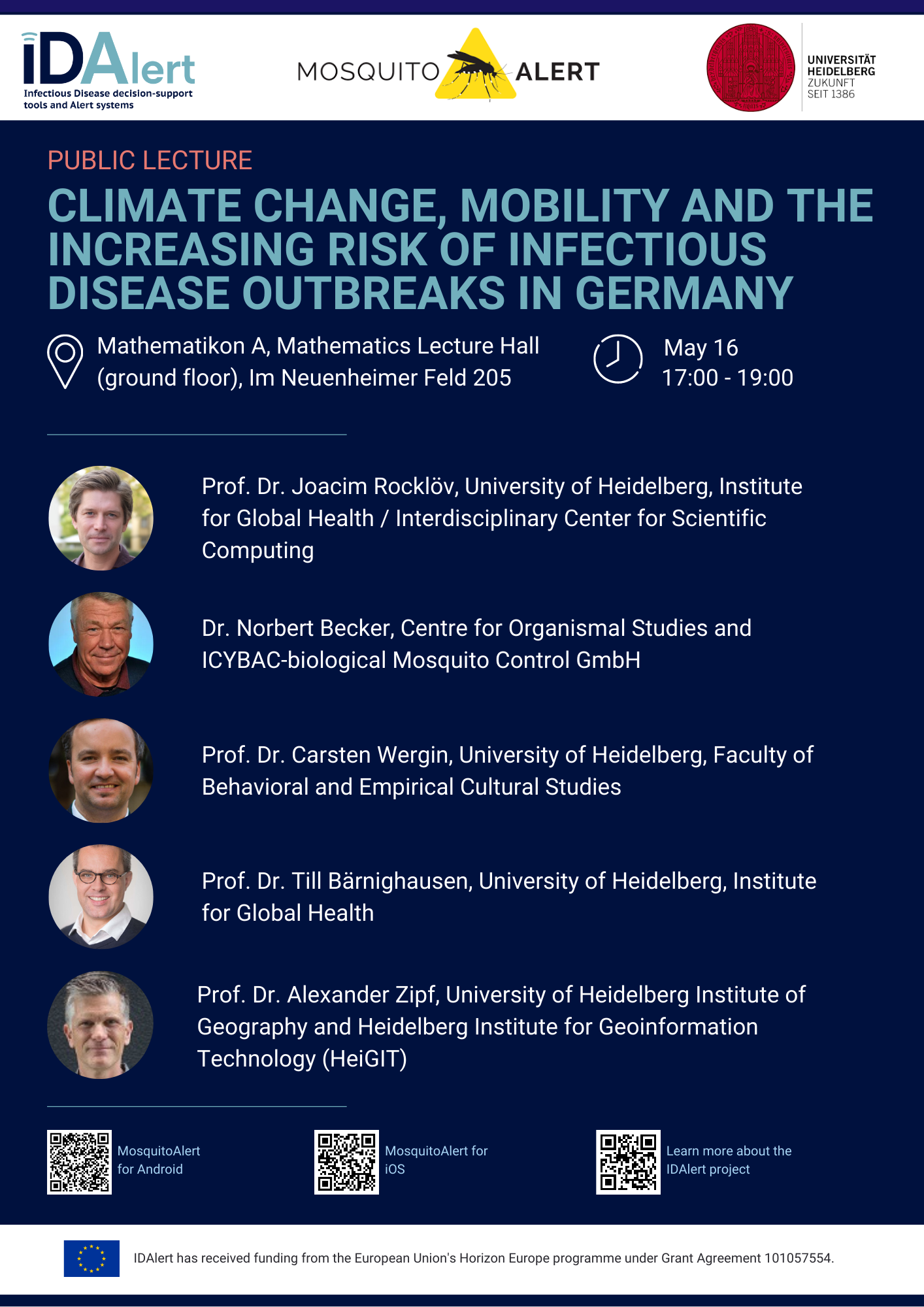
Upcoming Public Lecture May 16: Climate Change, Mobility, and the Increasing Risk of Infectious Disease Outbreaks in Germany
On Tuesday, May 16, visitors to the public lecture “Climate Change, Mobility, and the Increasing Risk of Infectious Disease Outbreaks in Germany” will be treated to insights from five experts currently pioneering research into one of the greatest threats to Germany’s public health. The event will occur in both German and English on the ground…
-
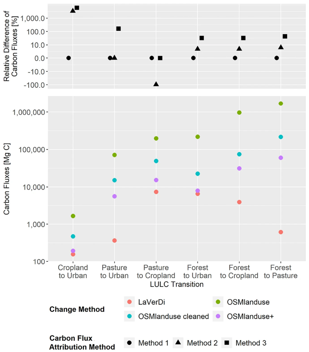
New Paper: Carbon Fluxes Related to Land Use and Land Cover Change in Baden-Württemberg
Featured Image: Figure 1. Total carbon fluxes related to LULCC in Baden-Württemberg between March 2018 and October 2019 (LaVerDi, OSMlanduse+), and March 2018 and March 2020 (OSMlanduse, OSMlanduse cleaned). The upper plot shows the relative difference of carbon fluxes [%] with respect to LULC transition and carbon flux attribution method. The carbon fluxes of method…
-
Mamapa/CartONG Event zu Interkultureller Kommunikation im Rahmen der “Internationalen Wochen gegen Rassissmus” 2023 – Fettnäpfchen erkennen und vermeiden lernen
Bereits seit 2016 werden jährlich die Internationalen Wochen gegen Rassissmus (IWgR) von der Stiftung gegen Rassismus koordiniert. In zahlreichen Veranstaltungen können in deren Rahmen Erfahrung gesammelt und ausgetauscht, informiert und vor allem Bewusstsein geschaffen und Engagement gefördert werden. Bereits seit 2019 unterstützt das Mamapa Projekt die IWgR durch Veranstaltungen. Mamapa wurde mit dem Ziel gegründet, die Integration von neu Zugewanderten (Migrant*innen bzw. Flüchtlingen)…
-
HeiGIT and GIScience Contributions to Last Year’s Conference-athon
With a new year of papers, workshops, and publications ahead of us, the team at GISciene and HeiGIT are looking back and building on the many contributions to last year’s conferences. During the previous summer’s FOSS-Community “conference-athon” in Florence, when QGIS-Meeting, State of the Map, HOT unSummit and FOSS4G all occurred in the same short span,…