

The newly released Sketch Map Tool v2.1 features a higher accuracy in digitizing hand-sketched markings on Sketch Maps, thanks to a larger training dataset and an updated machine learning model for sketch detection. New user metrics show that thousands of Sketch Maps are created every month all over the world.
The Sketch Map Tool
The Sketch Map Tool is an easy-to-use, open-source tool for participatory mapping through offline collection, digitisation and georeferencing of local data. This low-tech solution simplifies the gathering and analysis of spatial knowledge and perceptions using pens and paper maps, the so-called Sketch Maps.
Every Sketch Map contains a basemap with OpenStreetMap data or satellite imagery, which provides a scale and orientation. Upon uploading pictures of hand-marked maps, the tool automatically digitizes and georeferences the markings, making it downloadable for integration into Geographic Information Systems (GIS).
The Sketch Map Tool can be particularly useful for identifying areas susceptible to flooding or drought, pinpointing critical infrastructure and civil facilities within vulnerable zones, and in all other situations where harnessing knowledge from the local community is essential.
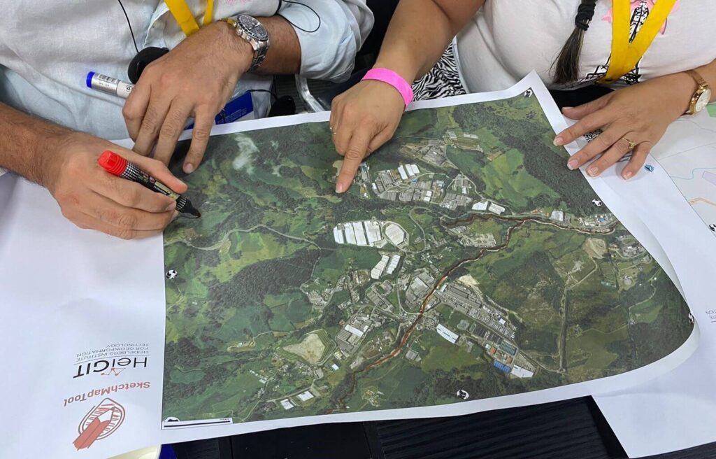
Volunteer mappers drawing on a Sketch Map
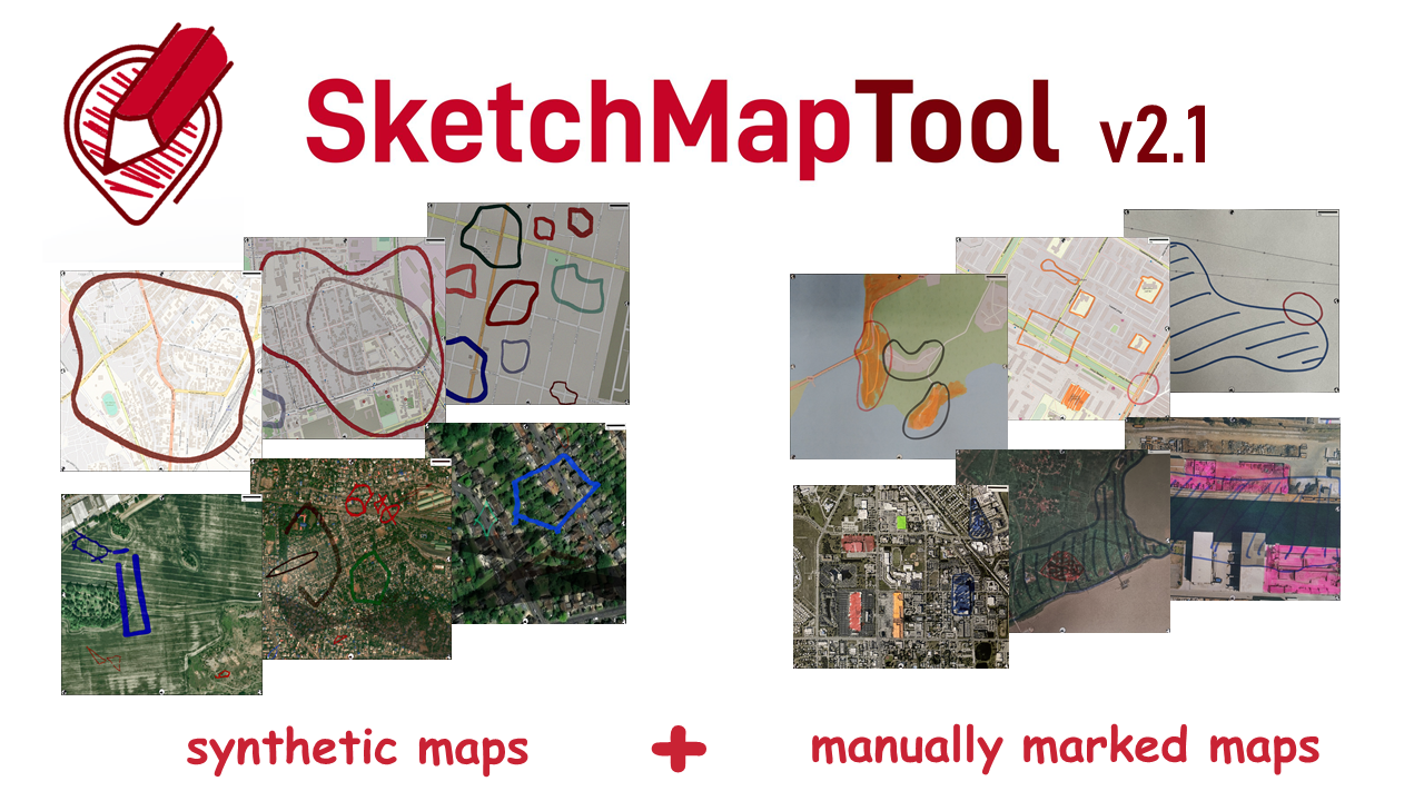
Sketch Map Tool v2.1: New Dataset and Enhanced Sketch Detection
The newly released Sketch Map Tool v2.1 offers an enhanced sketch detection, made possible by a larger training dataset that combines both manually-marked and synthetic sketch maps.
The key step for a more accurate detection model was the addition of a synthetic (computer-generated) training dataset of around 20,000 images. The synthetic dataset was then complemented by around 5,000 manually marked (hand-drawn) sketches, which included various styles and complexity of polygons and other shapes, further refining detection capabilities.
The combination of synthetic and manually marked sketch data, together with a larger training dataset for both OSM and ESRI map frames, allows Sketch Map Tool to interpret sketches with a higher accuracy and precision in different environments and with variable hand-drawing styles.

Machine Learning Model Updates and Release
Moreover, the machine learning model backbone has been updated, making it now possible to handle custom number band images using a/the YOLO detection model. We also upgraded the underlying segmentation model to SAM-2, which delivers a more accurate and faster segmentation task.
We are now releasing the models trained on our dataset, allowing users to benefit directly from our research and improvements. The Hand-drawn Shapes (HDS) Dataset can be found in this GitHub repository, while the trained YOLO models for sketch detection can be downloaded here.
Real-World Impact
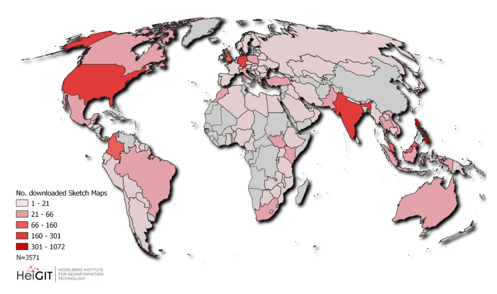
The Sketch Map Tool team has now also started gathering a few user metrics, such as the number of Sketch Maps created and their geographic location. The first available user statistics show a strong, worldwide usage of Sketch Map Tool:
- Since the last major release in March 2024, over 32,000 Sketch Maps were created.
- In just six weeks between December 2024 and January 2025, about 3,500 Sketch Maps were downloaded in 119 different countries around the world.
We strive to understand how, where and why the Sketch Map Tool is used, evaluating not only the numbers, but most importantly exploring its practical applications to better understand users´ needs, remove existing barriers, and increase the tool´s real-world impact.
We have already collected several case studies showcasing the use of Sketch Maps in Colombia, Timor Leste and Italy on the Sketch Map Tool website. We look forward to hearing about more use cases and diverse applications of the Sketch Map Tool.
For any inquiries or to share how you are using the Sketch Map Tool, you can write us at sketch-map-tool@heigit.org. To stay up to date on the Sketch Map Tool releases and case studies, you can subscribe to the Sketch Map Tool Newsletter. For a visual refresher on how to use the Sketch Map Tool, watch our quick video tutorial.