

Fig. 1: New feature: combining attributes
We recently added the attribute completeness indicator to the Ohsome Dashboard, and we’re now happy to introduce major upgrades to its functionalities.
The ohsome quality API (OQAPI) and the ohsome dashboard
The ohsome quality API was built to provide data quality estimations for OpenStreetMap data. There are currently four indicators that calculate the quality of OSM data: data currentness, mapping saturation, building/ road comparison and the attribute completeness indicator. The ohsome dashboard uses the ohsome quality API to create a more user- friendly experience and lower the barrier of entry for OSM data quality analysis. The newest release serves to make the attribute completeness indicator more versatile both in the API as well as the dashboard.
The Attribute Completeness indicator
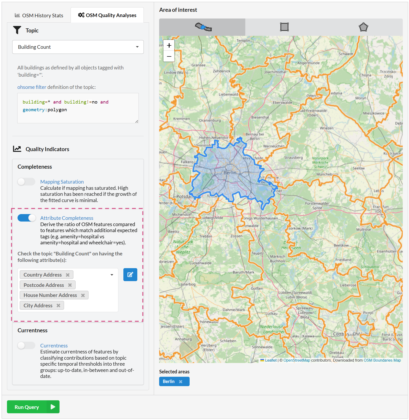
Previously, the attribute completeness indicator was made for finding the percentage of features in an area that have one specific additional attribute. For example, you could query it to calculate the percentage of buildings in an area that also have information about a house number.
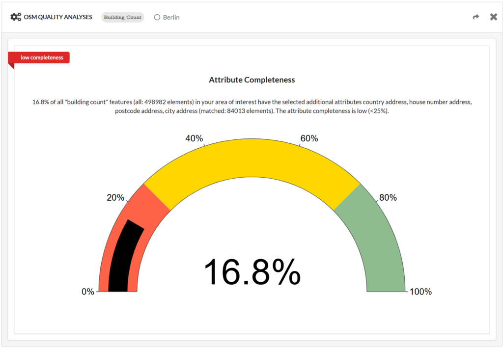
With the new update, you can create combined queries for multiple attributes at a time. Now, if you want to find the percentage of buildings in an area that have some more complete address information, you can combine attributes – for example country address, postcode address, house number and city address (fig. 1 and 2).
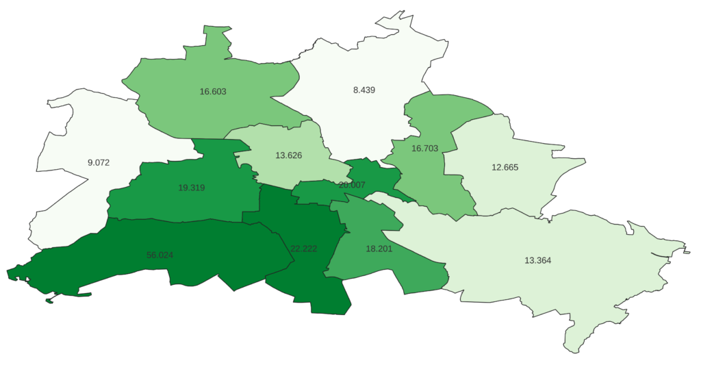
To give users even more freedom with what kind of attributes they want to query, we also added a custom filter option to let users create any key-value combination they want. If you want to analyze building construction over time for example, the OSM key “start_date” would be the one to look for. With this new feature, you can query the completeness of this attribute to check if the sample size in your area is big enough to justify using OSM data for the research (Fig. 3)
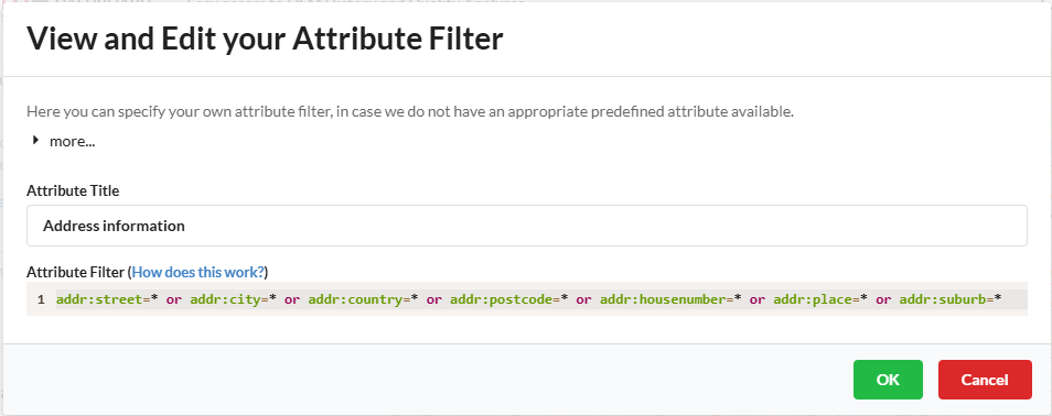
Since this custom attribute filter lets you define your attribute however you want, you can also make more complex attributes with the “and” / ”or” statements. Because of this, you can now also get the attribute completeness of buildings having any kind of address information among countless other new possibilities. The query with the custom attribute filter from Figure 4 shows a completeness of about 19.4% in Berlin for example, while only 18% of buildings in Berlin have the single attribute house number.
Together with these new features, we have also added some new topics (classified roads, public transport stops, and sports pitch) and many new or improved attributes.
Other changes
Apart from these improvements, some smaller changes have also been made – for example, the description text of the attribute completeness figure now includes more information about the selected topic and attributes. If you are interestend in learning more about the detailed changes of new releases, check out the Changelog of the Ohsome Quality API.
Future plans
We are always working on improving the user experience and adding new tools to experiment with. Some of the main points we are aiming to bring to you in the future are:
- custom topics (similar to the custom attribute filter that was just introduced)
- a new indicator that determines attribute accuracy of land use / land cover data on OSM
- potentially use GeoParquet files for some processes (for those interested, get a sneak peak here)
Want to try out the new features? Check out the ohsome dashboard, select one of the topics that supports the attribute completeness indicator and make your own combination of predefined/custom attributes or use the ohsome quality API.
To keep up with future developments and releases related to this project as well as other efforts to advance geospatial technology in the mobility, humanitarian aid, and data analytics space, follow our social media channels and stay u