

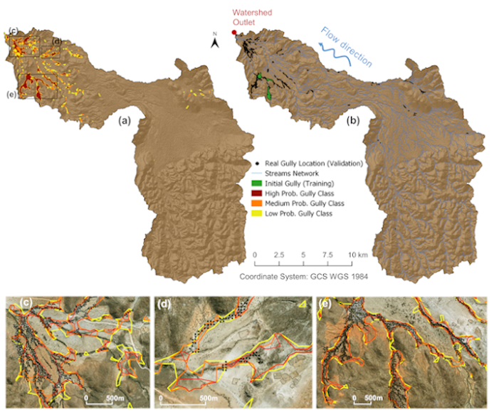
Gullies are landforms with specific patterns of shape, topography, hydrology, vegetation, and soil characteristics. Remote sensing products (TanDEM-X, Sentinel-1 and Sentinel-2) serve as inputs into an iterative algorithm, initialized using a micro-mapping simulation as training data, to map gullies in the northwestern of Namibia. A Random Forest Classifier examines pixels with similar characteristics in a pool of unlabeled data and gully objects are detected where high densities of gully pixels are enclosed by an alpha shape. Gully objects are used in subsequent iterations following a mechanism where the algorithm uses the most reliable pixels as gully training samples. The gully class continuously grows until an optimal scenario in terms of accuracy is achieved. Results are benchmarked with manually tagged gullies (initial gully labelled area <0.3% of the total study area) in two different watersheds (408 km2 and 302 km2, respectively) yielding total accuracies of >98%, with 60% in the gully class, Cohen Kappa >0.5, Matthews Correlation Coefficient >0.5, and ROC Area Under the Curve >0.89. Hence, our method outlines gullies keeping low false-positive rates while the classification quality has a good balance for the two classes (Gully/NoGully). Results show the most significant gully descriptors as the high temporal radar signal coherence (22.4%) and the low temporal variability in Normalized Difference Vegetation Index (NDVI) (21.8%).
This research builds on previous studies to face the challenge of identifying and outlining gully-affected areas with a shortage of training data using global datasets, which are then transferable to other large (semi-)arid regions.
Find all details in the full papers:
Orti, M.V., Winiwarter, L., Corral-Pazos-de-Provens, E., Williams, J.G., Bubenzer, O. & Höfle, B. (2020): Use of TanDEM-X and Sentinel products to derive gully activity maps in Kunene Region (Namibia) based on automatic iterative Random Forest approach. IEEE Journal of Selected Topics in Applied Earth Observations and Remote Sensing.
Orti, M.V., Negussie, K., Corral-Pazos-de-Provens, E., Höfle, B. & Bubenzer, O. (2019): Comparison of Three Algorithms for the Evaluation of TanDEM-X Data for Gully Detection in Krumhuk Farm (Namibia). Remote Sensing. Vol. 11 (11), pp. 1-22.
This research is part of the DEM_HYDR2024 project supported by TanDEM-X Science Team, therefore we would like to express thanks to the Deutsches Zentrum für Luft-und Raumfahrt (DLR) as the donor for the used TanDEM-X datasets. We acknowledge the financial support provided by the Namibia University of Science and Technology (NUST) within the IRPC research funding programme and to ILMI for the sponsorship of field trips to identify suitable study areas. Finally, we would like to express gratitude towards Heidelberg University and the Kurt-Hiehle-Foundation for facilitating the suitable work conditions during this research.