

How can multiple processes related to the deformation of an active rock glacier operating over different timescales be separated from each other?
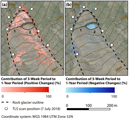
A preprint on the disaggregation of surface change mechanisms of a rock glacier has recently been published on Earth Surface Dynamics Discussions, an interactive open access journal of the European Geosciences Union. It presents a method drawing on terrestrial LiDAR monitoring at sub-monthly intervals to quantify the relative contribution of 3D surface change during a three-week period of snow-free conditions to the annual surface change. Changes are also separated according to their direction.
The study shows that different directions of surface change are dominant at different times of the year. Our results demonstrate the benefit of more frequent LiDAR monitoring and, critically, the requirement of novel approaches to detecting change, as a step towards interpreting the mechanisms that underlie the surface change of rock glaciers.
Find all details in the full preprint:
Ulrich, V., Williams, J.G., Zahs, V., Anders, K., Hecht, S., Höfle, B. (2020): Disaggregating surface change mechanisms of a rock glacier using terrestrial laser scanning point clouds acquired at different time scales. Earth Surf. Dynam. Discuss. https://doi.org/10.5194/esurf-2020-55, in review.
The rock glacier Äußeres Hochebenkar has been studied by the 3DGeo research group for the developement of methods for surface change quantification for several years. You can find more information on the related AHK-4D project on the project website and in the project video.
Related research:
Zahs, V., Hämmerle, M., Anders, K., Hecht, S., Rutzinger, M., Sailer, R., Williams, J.G., Höfle, B. (2019): Multi-temporal 3D point cloud-based quantification and analysis of geomorphological activity at an alpine rock glacier using airborne and terrestrial LiDAR. Permafrost and Periglacial Processes. Vol. 30 (3), pp. 222-238. https://doi.org/10.1002/ppp.2004.
Multi-temporal terrestrial LiDAR datasets of the rock glacier Äußeres Hochebenkar have been openly published on PANGAEA:
Pfeiffer, J., Höfle, B., Hämmerle, M., Zahs, V., Rutzinger, M., Scaioni, M., Lindenbergh, R., Oude Elberink, S., Pirotti, F., Bremer, M., Wujanz, D. & Zieher, T. (2019): Terrestrial laser scanning data of the Äußeres Hochebenkar rock glacier close to Obergurgl, Austria acquired during the Innsbruck Summer School of Alpine Research. PANGAEA. DOI: https://doi.pangaea.de/10.1594/PANGAEA.902042 .