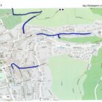
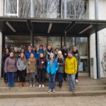
A week ago, students from the seminar “User-Generated Geographic Data in Disaster Risk Management and Humanitarian Aid” carried out a survey about urban flood risk in Handschuhsheim. The “field day” was organised by Carolin Klonner and Melanie Eckle (the teachers of the seminar) in cooperation with Kai Schaupp and Dr. Raino Winkler of the environmental agency of the city of Heidelberg. First, Kai Schaupp gave an interesting talk about the flood risk situation in Heidelberg, especially in the hillside area of Handschuhsheim. Then we started our practical work in Handschuhsheim all around Mühltalstraße and Steckelsgasse, using participatory mapping with Field Papers and the questionnaire tool ODK-Collect to collect information about affected areas and to explore the flood experience and risk perception of local citizens. In the conversations with local citizens we got interesting information about the high spatial divergences of flooding impacts and damages. Moreover, we learned that the understanding of risk is quite different in general and between neighbours. Results will also be used by the environmental agency and further collaborations are planned. In conclusion, it was a successful day with lots of quite personal and emotional insights in the flood perception of local citizens and a good start for further studies.