

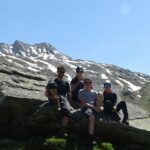
From 22 – 25 June, the first field visit within the project AHK-4D – High-resolution and high-frequency monitoring of the rock glacier Äußeres Hochebenkar (AHK) in Austria took place in the Austrian Alps.
The aim of this project is to develop a methodology to quantify the magnitudes and frequencies of individual surface change processes of a rock glacier over several years. We do this by analyzing three dimensional (3D) surface change based on high-resolution, high-frequency and multisource LiDAR data. The derived information will enable us to develop methods to automatically characterize and disaggregate multiple processes and mechanisms that contribute to surface change signals derived from less frequent monitoring (e.g. yearly). Such methods can enhance our general understanding of the spatial and temporal variability of rock glacier deformation and the interaction of rock glaciers with connected environmental systems.
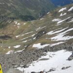
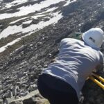
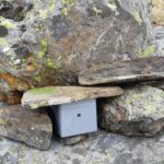
During this first field campaign a measurement network was installed at the active rock glacier Äußeres Hochebenkar – AHK (Ötztal valley, Austria) in order to acquire high spatial- and high temporal (e.g. bi-weekly)- resolution and multisource (terrestrial and UAV-borne LiDAR) topographic LiDAR data. Stable reflector measurements with Tachymeter and RTK GNSS were carried out in order to enable accurate co-registration of sequential TLS and ULS datasets.These data are complemented by time-lapse cameras and subsurface electrical resistivity tomography measurements for comparison.
The AHK-4D project is a joint research project between the the 3DGeo Research Group and Geomorphology and Soil Geography Research Group (Institute of Geography, Heidelberg University) and the Institute of Geography of the University of Innsbruck.
Find more details about the AHK-4D project on the project website and follow us on Twitter.
The AHK rock glacier has already been investigated by the 3DGeo group for many years and has been visited at several occasions, e.g. in the frame of student field trips and the Innsbruck Summer School of Alpine Research.
Zahs, V., Hämmerle, M., Anders, K., Hecht, S., Rutzinger, M., Sailer, R., Williams, J.G., Höfle, B. (2019): Multi-temporal 3D point cloud-based quantification and analysis of geomorphological activity at an alpine rock glacier using airborne and terrestrial LiDAR. Permafrost and Periglac Process. 2019;1-17. DOI: https://doi.org/10.1002/ppp.2004.
The AHK rock glacier will also be examined in a related research project (Geomorph4D), with the aim of exploring the importance of rockfalls and talus accumulation at the headwall of rock glaciers, and to examine this within the context of changing climate conditions, and therefore stresses, within paraglacial environments.
Interested in using LiDAR data acquired at the AHK rock glacier for your own research? – Multi-temporal terrestrial laser scanning datasets at the AHK rock glacier are openly provided on PANGAEA:
Pfeiffer, J., Höfle, B., Hämmerle, M., Zahs, V., Rutzinger, M., Scaioni, M., Lindenbergh, R., Oude Elberink, S., Pirotti, F., Bremer, M., Wujanz, D. & Zieher, T. (2019): Terrestrial laser scanning data of the Äußeres Hochebenkar rock glacier close to Obergurgl, Austria acquired during the Innsbruck Summer School of Alpine Research. PANGAEA. DOI: https://doi.pangaea.de/10.1594/PANGAEA.902042.