

From 01-04 April 2019, the 3DGeo and FCGL research groups organized STAP19, a compact course and workshop on Spatial and Temporal Analysis of Geographic Phenomena at the Interdisciplinary Center for Scientific Computing (IWR, Heidelberg University).
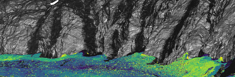
In a mix of lectures, invited talks and hands-on sessions, the participants learned about processing and analysis of 3D geodata, particularly in the point cloud domain using topographic LiDAR, as well as the use and visualization of 3D meshes. The sessions were held by various researchers of the organizing groups: Dr. Hubert Mara, Dr. Jack G. Williams, Dr. Bartosz Bogacz, Lukas Winiwarter.
Several guests joined STAP19
Prof. Dr. Andreas Nüchter (University of Würzburg, Germany) presented recent work of his Robotics and Telematics group, including a demonstration of an underwater scanner. In a hands-on, he taught participants the use of the 3D Toolkit for efficient 3D point cloud processing. The 3D Toolkit provides a range of ready-to-use algorithms and methods, e.g. automatic registration, plane extraction or the “peopleremover”, and a fast 3D viewer.
Dr. Gottfried Mandlburger (Institute for Photogrammetry, University of Stuttgart) introduced methods of information extraction from geographic 3D point clouds and gave important considerations on the derivation of features from 3D point neighborhoods. He is a main developer of the point cloud processing software OPALS (GEO Department, TU Vienna) and a hands-on introduction to geographic point cloud analysis with OPALS followed up his talk, led by 3DGeo member and TU Vienna alumnus Lukas Winiwarter.
Jorge Martínez Sánchez (CiTIUS, University of Santiago de Compostela, Spain) joined the workshop as one of the main developers of the Heidelberg LiDAR Operations Simulator (HELIOS) for laser scanning simulations of virtual scenes. In his talk, he presented the concept of HELIOS, applications and most recent developments as well as an outlook on future plans. One of the planned new features – support of elliptical footprints – formed part of a programming challenge taken up by a team of the participant group and might soon be available in the HELIOS source code. After his hands-on, the participants are now well-equipped for virtual field work for survey planning, synthetic ground-truthing and testing of methods.
In the second part of the event, participants worked on their own tasks in small teams in the frame of a programming and research challenge, which they presented to the groups as a conclusion of the workshop. This important part of STAP19 was made possible by the motivation and enthusiasm of the participants! It was amazing how the great variability in the backgrounds of participants (geography, computer science, mathematics, scientific computing, art history, geo-ecology, architecture, geomatics, photogrammetry and remote sensing, …) -who made their journey from many different institutions (German and international)- enhanced the joint experience and gave way for fruitful exchanges and networking opportunities.
The text was too long to read? Or you made it all the way to the end and really deserve it! Find some impressions of STAP19 below and check the character-limited updates on twitter (#STAP19).
STAP19 was organized by Katharina Anders, Prof. Dr. Bernhard Höfle, and Dr. Hubert Mara. We thank everyone who contributed to the success of STAP19 – on stage and behind the scenes!
The event took place at the Interdisciplinary Center for Scientific Computing (IWR) and was sponsored by the Heidelberg Graduate School of Mathematical and Computational Methods for the Sciences (HGS MathComp), founded by DFG grant GSC 220 in the German Universities Excellence Initiative.