

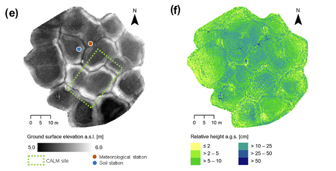
A 16-year record (2002–2017) of permafrost, active-layer, and meteorological conditions at the Samoylov Island Arctic permafrost research site, Lena River delta, northern Siberia was just published in Earth System Science Data. The long-term observational data is complemented by high-resolution topographic data acquired by terrestrial laser scanning (TLS) in 2017, when the 3DGeo Research Group joined the German-Russian expedition of the Alfred Wegener Institute (AWI) for Polar and Marine Research to the Arctic research station Samoylov (N 72°22’, E 126°29’) in the central Lena Delta. Catch up on this exciting field campaign in the related blog post.
The TLS point clouds, together with the derived terrain and vegetation rasters, are openly provided on PANGAEA. Find out about the important background of permafrost research and long-term observations in the paper:
Boike, J., Nitzbon, J., Anders, K., et al. (2019): A 16-year record (2002–2017) of permafrost, active-layer, and meteorological conditions at the Samoylov Island Arctic permafrost research site, Lena River delta, northern Siberia: an opportunity to validate remote-sensing data and land surface, snow, and permafrost models, Earth Syst. Sci. Data, 11, 261-299, https://doi.org/10.5194/essd-11-261-2019.
Interested in further datasets from Arctic permafrost sites? The multisensor multitemporal data acquired in the PermaSAR project in Arctic Canada have already been fully published, as well as an airborne laserscanning dataset of the same region:
Anders, K., Antonova, S., Beck, I., Boike, J., Höfle, B., Langer, M., Marsh, P., Marx, S., (2018): Multisensor ground-based measurements of the permafrost thaw subsidence in the Trail Valley Creek, NWT, Canada, 2015-2016. Alfred Wegener Institute, Helmholtz Center for Polar and Marine Research, Bremerhaven, PANGAEA, DOI: 10.1594/PANGAEA.888566.
Anders, Katharina; Antonova, Sofia; Boike, Julia; Gehrmann, Martin; Hartmann, Jörg; Helm, Veit; Höfle, Bernhard; Marsh, Philip; Marx, Sabrina; Sachs, Torsten (2018): Airborne Laser Scanning (ALS) Point Clouds of Trail Valley Creek, NWT, Canada (2016). PANGAEA, DOI: 10.1594/PANGAEA.894884
The PermaSAR project is funded by the BMWi/DLR in the framework “Entwicklung von innovativen wissenschaftlichen Methoden und Produkten im Rahmen der TanDEM-X Science Phase”.