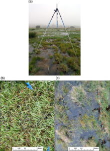
Knowledge about the magnitude of localised flooding of riverine areas is crucial for appropriate land management and administration at regional and local levels. However, detection and delineation of localised flooding with remote sensing techniques are often hampered on floodplains by the presence of herbaceous vegetation.
To address this problem, our very recent paper presents the application of full-waveform airborne laser scanning (ALS) data for detection of floodwater extent. In general, water surfaces are characterised by low values of backscattered energy due to water absorption of the infrared laser shots, but the exact strength of the recorded laser pulse depends on the area covered by the targets located within a laser pulse footprint area. To account for this we analysed the physical quantity of radiometrically calibrated ALS data, the backscattering coefficient, in relation to water and vegetation coverage within a single laser footprint.
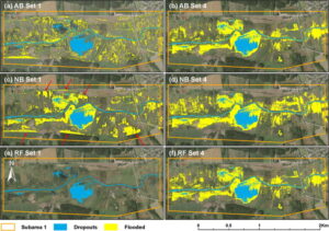
The results showed that the backscatter was negatively correlated to water coverage, and that of the three distinguished classes of water coverage (low, medium, and high) only the class with the largest extent of water cover (>70%) had relatively distinct characteristics that can be used for classification of water surfaces. Following the laser footprint analysis, three classifiers, namely AdaBoost with Decision Tree, Naïve Bayes and Random Forest, were utilised to classify laser points into flooded and non-flooded classes and to derive the map of flooding extent. The performance of the classifiers is highly dependent on the set of laser points features used. Best performance was achieved by combining radiometric and geometric laser point features. The accuracy of flooding maps based solely on radiometric features resulted in overall accuracies of up to 70% and was limited due to the overlap of the backscattering coefficient values between water and other land cover classes. Our point-based classification methods assure a high mapping accuracy (∼89%) and demonstrate the potential of using full-waveform ALS data to detect water surfaces on floodplain areas with limited water surface exposition through the vegetation canopy.
A free copy of the article can be downloaded here: http://authors.elsevier.com/a/1THyf3I9x1NPYK.
Citation: Malinowski, R., Höfle, B., Koenig, K., Groom, G., Schwanghart, W. & Heckrath, G. (2016): Local-scale flood mapping on vegetated floodplains from radiometrically calibrated airborne LiDAR data. ISPRS Journal of Photogrammetry and Remote Sensing. Vol. 119 (0), pp. 267-279.


