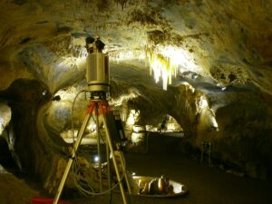
In one of Germany’s most visited show caves, the Dechen Cave near Iserlohn, different objects were captured with the GIScience‘s high-end terrestrial laser scanner Riegl VZ-400 and the low-cost structured light camera Microsoft Kinect™ by Johannes Fuchs, Bernhard Höfle, Martin Hämmerle (LiDAR Research Group) and Andrea Schröder-Ritzrau (Institute of Environmental Physics). Morphometric features that are important in speleology (e.g., diameter, length, volume) were derived from the point clouds of a stalagmite called ‘Palme’ and a flowstone wall in the ‘Pulpit Grotto’, and used for comparing the sensors.


Depending on the scanned object’s surface geometry and the scanning set-up, the Kinect™ data show only small deviations from the LiDAR reference. Surfaces of high curvature and subtle convex structures, as in case of the ‘Palme’ stalagmite, are not as well represented by the Kinect™ data as in case of the flowstone wall. However, the Kinect™ can be considered a valuable additional source of 3D geodata. Due to its small size it can be used for capturing areas that are hard to access. Additionaly, the equipment’s low costs and easy handling make it an interesting device for multi-temporal 3D acquisition and citizen science projects.

Further reading:
Hämmerle, M., Höfle, B., Fuchs, J., Schröder-Ritzrau, A., Vollweiler, N. & Frank, N. (2014): Comparison of Kinect and Terrestrial LiDAR Capturing Natural Karst Cave 3D Objects. In: IEEE Geoscience and Remote Sensing Letters. Accepted for publication, doi:10.1109/LGRS.2014.2313599.
The point cloud of the ‘Pulpit Grotto’ can be viewed online here, the point clouds of the ‘Palme’ stalagmite and the flowstone wall are provided at www.pangaea.de (doi:10.1594/PANGAEA.830567).
Special thanks to Dr. Stefan Niggemann and Rasmus Dreyer for guiding and supporting the scanning campaign in the Dechen Cave!


