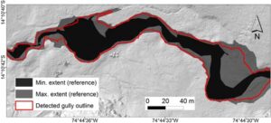
Cushion peatlands are typical features of the high altitude Andes in South America. Due to the adaptation to difficult environmental conditions, they are very fragile ecosystems and therefore vulnerable to environmental and climate changes. Peatland erosion has severe effects on their ecological functions, such as water storage capacity. Thus, erosion monitoring is highly advisable. Erosion quantification and monitoring can be supported by high-resolution terrestrial Light Detection and Ranging (LiDAR). In this study, a novel Geographic Information System (GIS)-based method for the automatic delineation and geomorphometric description of gullies in cushion peatlands is presented. The approach is a multi-step workflow based on a gully edge extraction and a sink filling algorithm applied to a conditioned digital terrain model. Our method enables the creation of GIS-ready polygons of the gullies and the derivation of geomorphometric parameters along the entire channel course. Automatically derived boundaries and gully area values correspond to a high degree (93%) with manually digitized reference polygons. The set of methods developed in this study offers a suitable tool for the monitoring and scientific analysis of fluvial morphology in cushion peatlands.
Citation: Höfle, B., Griesbaum, L. & Forbriger, M. (2013): GIS-Based Detection of Gullies in Terrestrial LiDAR Data of the Cerro Llamoca Peatland (Peru). Remote Sensing. Vol. 11(5), pp. 5851-5870.


