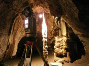
Researchers of the GIScience research group of the Institute of Geography, the Institute of Environmental Physics of the University of Heidelberg and the Heidelberg Academy of Sciences and Humanities acquired a highly accurate 3D topographic point cloud of the Dechenhöhle, which is attached to the Speleology Museum Dechenhöhle Caves.
Terrestrial laser scanning and low-cost sensing devices were applied to capture a detailed 3D representation of the cave and its speleothems. Speleothems have high importance as paleoclimate archives. It is expected that the 3D location and geometric characteristics of single forms allow increasing the understanding of the complex formation processes.
– Local press release


