

Tag: LOKI
-
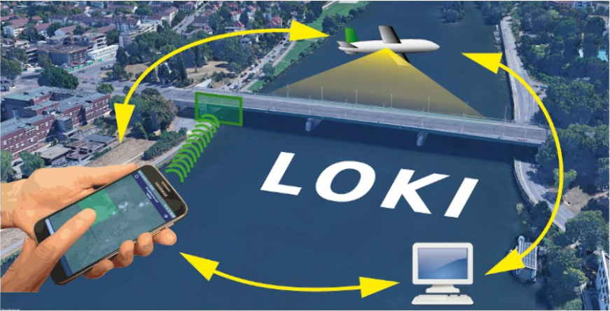
The LOKI Project: Rapid Earthquake Damage Assessment
In the aftermath of earthquakes, rapid and accurate assessment of infrastructure damage is crucial. The LOKI project (Airborne Observation of Critical Infrastructures), funded by the Federal Ministry for Education and Research and active from January 1, 2020, to March 31, 2023, aimed to tackle this challenge. Bringing together expertise from diverse research fields including earthquake…
-
🦇 Halloween release of HELIOS++, v1.3.0
We proudly present our Halloween release of HELIOS++, Version 1.3.0: https://github.com/3dgeo-heidelberg/helios/releases What’s new in this release? HELIOS++ now supports LiDAR simulation of dynamic scenes. We can now simulate laser scanning of scenes that change during the simulation. This is done by introducing rigid motions, which are defined with XML syntax in the scene XML file.…
-
Preview of 3DGeo @ EGU 2022 – Meet us there
The 3DGeo Research Group will present some of their latest research at EGU General Assembly 2022. We are looking forward to meet you at the following talks: Virtual Laser Scanning using HELIOS++ – Applications in Machine Learning and Forestry: The presentation provides an introduction to VLS, possible use cases, pitfalls and best practices for successful…
-
New Paper: Correspondence-driven plane-based M3C2 for lower uncertainty in 3D topographic change quantification
Check out our new paper presenting a novel approach (correspondence-driven plane-based M3C2) to lower the uncertainty in 3D topographic change quantification (get free access here until 2 February 2022) Zahs, V., Winiwarter, L., Anders, K., Williams, J.G., Rutzinger, M. & Höfle, B. (2022): Correspondence-driven plane-based M3C2 for lower uncertainty in 3D topographic change quantification. ISPRS…
-
MapSwipe is App of the Day in Apple AppStore
MapSwipe has ben announced as ‘App of the Day‘ in the Apple AppStore! (27.08.2021) Thank you to all our volunteers for the continued help and support which keeps the app going. Read the blogpost here: https://apps.apple.com/ca/story/id1559236909 The team at the Heidelberg Institute for Geoinformation Technology (HeiGIT) and the GIScience Research Group at Heidelberg University has shaped MapSwipe’s…
-
LOKI at vEGU 2021 on 26 and 29 April
Join us and many European researchers from the Earth, planetary and space sciences in the virtual European Geosciences Union (EGU) assembly from 19 to 30 April 2021! Are you interested in innovative methods and concepts applied to natural hazards? Then join our 2-minute talks on research within the LOKI project on Monday, 26 April, and…
-
LOKI – Video on UAV-based damage assessment combining automated methods with Micro-Mapping
Interested in how earthquake-induced damage to critical infrastructures is assessed in the research project LOKI? Then check out this teaser below! Link to video In the LOKI project (Luftgestützte Observation Kritischer Infrastrukturen; Airborne Assessment of Critical Infrastructures), an interdisciplinary system that enables fast and reliable airborne situation assessments following an earthquake is being developed by…
-
OSM completeness mapping for airborne situation assessment following an earthquake
As part of the LOKI project (Luftgestützte Observation Kritischer Infrastrukturen), a first test run of a newly launched OpenStreetMap (OSM) completeness mapping project in MapSwipe has been conducted yesterday. The aim of the LOKI project is to develop an interdisciplinary system that enables fast and reliable airborne situation assessments following an earthquake. The system will…
-
New project: LOKI – Airborne Observation of Critical Infrastructures
On Feb 12, 2020, the kick-off meeting for the newly funded BMBF project LOKI – Airborne Observation of Critical Infrastructures (Luftgestützte Observation Kritischer Infrastrukturen) was hosted by the GIScience and 3DGeo research groups of Heidelberg University. The aim of the LOKI project is to develop an interdisciplinary system that enables fast and reliable airborne situation…