

The 15-minute city concept is gaining traction in urban planning, aiming to ensure that essential services are within a short walk or bike ride. As the older population grows, walking remains a key factor in their well-being, yet their mobility is highly dependent on the built environment. A new research project, Silver Ways, is tackling this challenge by developing a navigation system specifically designed for older adults, integrating it into a Silver 15-Minute Neighborhood Index. Rather than simply suggesting the shortest route, this system prioritizes accessibility, safety, and ease of movement, making cities more walkable for seniors.
Silver Ways is an international research initiative, co-funded by the European Union under the Driving Urban Transitions (DUT) program, running from February 2025 to June 2027. The project brings together experts in GIScience, urban studies, and behavioral economics from Heidelberg University and HeiGIT (Germany), Uppsala University (Sweden), and Abdullah Gül University (Turkey). In collaboration with the cities of Mannheim, Uppsala, and Kayseri, it aims to provide data-driven, real-world solutions to improve urban mobility for seniors.
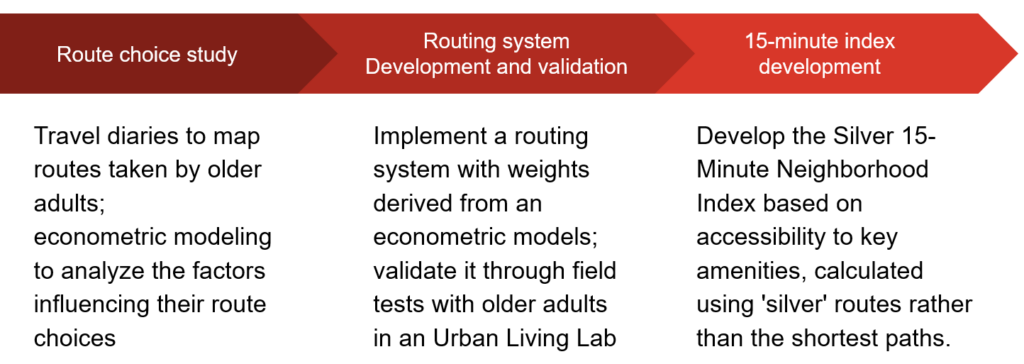
The project unfolds in three main stages. In the first year, Silver Ways conducts a Route Choice Study, led by Prof. Umut Türk from Abdullah Gül University. This involves collecting travel diaries from older adults, distributing paper maps, and digitizing their route choices to identify influential factors. Using open GIS data and street view imagery, researchers analyze elements such as sidewalk quality, slope, and greenery. These insights feed into an econometric route choice model, generating alternative walking routes tailored to senior mobility needs.
In the second year, the focus shifts to Routing System Development and Validation, coordinated by Dr. Kathrin Foshag from TDLab, Heidelberg University. The team translates the choice model into a real-world navigation system, integrating it with openrouteservice and customizing routing weights based on accessibility priorities. Urban Living Labs in Mannheim, Uppsala, and Kayseri will recruit senior participants for interactive urban walks, gathering feedback to refine the system.
In the final phase, Silver Way develops the Silver 15-Minute Neighborhood Index, led by Prof. Marina Toger and Prof. John Östh from Uppsala University. This stage involves mapping accessibility to key amenities—such as healthcare, parks, and shopping centers—using the optimized “silver” routes. Researchers will calculate travel times, assess walkability, and propose urban planning improvements, ensuring that the shortest paths are also the most senior-friendly.
For more details and updates, visit the project`s website (available in English, German, Swedish, and Turkish). To keep up with future developments and releases related to this project as well as other efforts to advance geospatial technology in the mobility, humanitarian aid, and data analytics space, follow our social media channels and stay up to date on our blog.