

Context
During natural disasters and other catastrophic events, quickly identifying and distributing resources is essential. Even a brief delay in evacuating residents or sourcing water can significantly hamper relief efforts and prevent effective disaster management. The HeiGIT and GIScience teams have been actively designing tools to assist in disaster preparation and response, from working with partners to build community resilience to activating our disaster portal after devastating earthquakes. One of our ongoing projects, GeoAI4Water 2, currently privately funded by KSB Group, represents a key tool in our endeavors to better prepare governments and responders for such events.
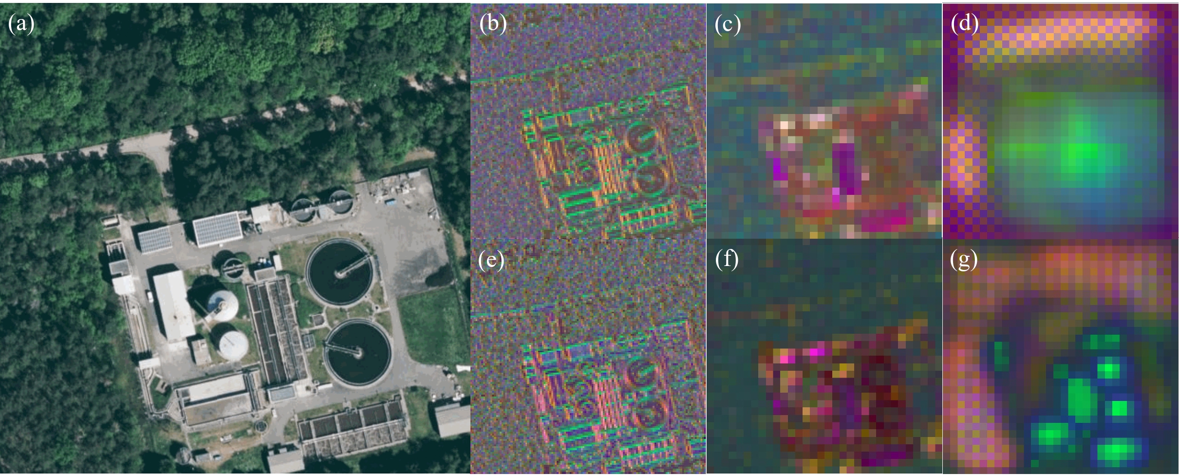
GeoAI4Water 2 seeks to detect Wastewater Treatment Plants (WTPs) as critical water infrastructure using hi-resolution satellite imagery, an invaluable step for understanding the quantity and location of resources. To manually evaluate and tag each image for such infrastructure would prove overwhelmingly costly and time-consuming, deterring many without the financial or labor capability to support this crucial task. Therefore, the project employs deep learning algorithms to detect this critical infrastructure in developing countries.
Addressing data gaps across diverse global regions demands a robust strategy capable of precisely yielding detection outcomes from earth observation data. A significant challenge arises from the considerable heterogeneity in satellite imagery and the varying features of specific ground objects, such as WTPs. HeiGIT’s objective has been to create extensive WTP datasets with applications ranging from Critical Water Infrastructure mapping to Urban Planning and Climate Action. Achieving this necessitates the development of a reliable deep learning pipeline with the ability to scale up globally, even in challenging rural and urban contexts. The GeoAI4Water 2 project effectively tackled this challenge and presented its key findings in the associated paper.
Our Approach
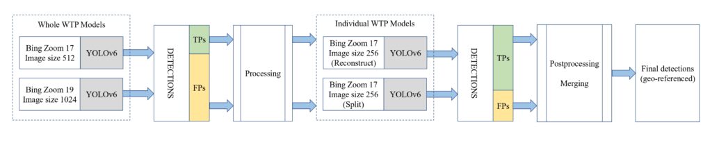
To overcome these challenges, HeiGIT introduced an innovative multiscale multifeature hybrid model that demonstrated high-quality results across diverse global regions. The proposed methodology involves hybridizing a DL workflow through the fine-tuning of vision-based representation learning at various spatial resolutions and from different data perspectives (whole vs. parts). The model capitalizes on the capabilities of deep learning-based object detection models, specifically Yolov6, RTMDET, EfficientDET, and Domain Adaptation, to precisely and efficiently identify WTP locations worldwide. The emphasis is on performance improvements, including the reduction of false positives (FPs) and achieving broad coverage. Strategies for these enhancements encompass effective data processing methods, model tuning, and adaptation. Additionally, we optimize the features of training data using Volunteered Geographic Information (VGI) data.
Multifeature and Multiscale Models involve training multiple DL Models at selected spatial resolutions and image sizes, thereby allowing different tuning knobs for capturing varying details with respect to satellite images. The selected parameters would be a function of the spatial dimensions of the detection object in question. An overview of the proposed hybrid methodology is also depicted in Figure below.
Some key findings are:
- In our hybrid approach, we selected optimized baseline models, demonstrating significant outperformance of single models. In terms of real-world implementation, we typically observe that FPs are a multiple (3X to 10X) of actual detections. But in our case, we used an improved approach that could effectively bring down the FPs to just a fraction of actual detections.
- YOLOv6 significantly improved detection and classification by 10 p.p (percentage points) and 6 p.p, respectively, compared to RTMDET and EfficientDET models.
- A clean dataset further boosted performance by 6 p.p and 4 p.p in classification and detection tasks, respectively. However, overcleaning the dataset hindered the model’s ability to generalize and influenced data size.
- Training on whole WTPs resulted in a notable performance boost, with a 9.5 p.p increase for detection and 4 p.p increase for classification compared to models trained on individual features.
- In the paper, we demonstrated the effectiveness of the suggested approach for three diverse global regions: Germany, France, and Malaysia. One of the most important outcomes are the new findings of the model. They refer to wastewater treatment plants that did not show up either in OSM or in one of the other databases we used to define our ground truth. Therefore, these findings add new insight and
knowledge about the tested areas and create added value. The study gives new insights into WTP distribution when compared to existing databases like OpenStreetMap (OSM).
Given the production quality of these results, we have developed automated workflows for large-scale global implementation. For the state of Vermont, USA, GeoAI4Water generated several new findings ( 100% – 300% more data than OSM depending on the type of WTP).
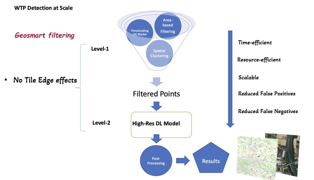
The number of images scanned for a region usually expands to hundreds of thousands or even millions when high-resolution satellite imagery is divided into smaller images used for training deep learning models. However, in our case, we developed a Geosmart filtering technique to narrow down the search to a few probable images as shown below:
Throughout the development of this project, new HeiGIT tools like the multiscale ohsome2label were developed to support automatic multiscale and multifeature labelling for various datasets. Additionally, tools like AIR-MAPPER were developed to visualize model inference in real-time, applicable to any part of the globe. Any DL model (ONNX format, Input 256 X 256 supported currently) on Satellite Imagery globally can be evaluated here.
The Benefit:
Accurate identification of essential infrastructure, such as WTPs, is crucial for urban planning, climate action, and more, especially in developing regions where alternative data sources may be limited. Detecting WTPs through earth observation data poses a significant challenge due to diverse data, encompassing variations in appearance, shape, size, and texture of these plants. Previous AI-based studies have confirmed the difficulty in developing a robust global model that ensures extensive detections of true positives (TPs) while significantly minimizing false positives (FPs).
Our Lead Machine Learning For Good, Dr. Randhawa, envisions a broader deployment of data globally, with a particular focus on the Global South in Asia and Africa, where the demand for resource mapping is significantly higher. Priorities will likely include countries at risk of disasters such as drought to improve climate change mitigation strategies and a further goal of applying the technology to other sectors such as the energy sector. In the OpenStreetMap community, the project could have further implications for land use and extra features to enrich OSM data.
The study has paved way for many interesting applications that go beyond detection of WTPs. The team is currently working on deriving new information/attributes for plant capacity estimation. Moreover, this study lays the foundation for further work on GeoAI-based models with in-built spatial knowledge or models that learn local features and patterns to improve local precision.
To keep up with future developments and releases related to this project as well as other efforts to advance geospatial technology in the mobility, humanitarian aid, and data analytics space, follow our social media channels and stay up to date on our blog.
Acknowledgements:
We are grateful for the financial support and valuable cooperation provided by the KSB Group throughout the project. Led by Dr. Sukanya Randhawa, our Machine Learning Lead for Good, the project includes the development of remote sensing-based filtering by Dr. Yulia Grinblat, exploration of domain adaptation techniques by PhD student Yuze Li for varied geo-regions. The creation of AIR-Mapper and Multiscale ohsome2label within HeiGIT involved valuable contributions from Dr. Michael Auer, Raphael Troilo, and Mohammed Rizwan Khan. Research students Daniel Abanto and Omer Olchik have helped with final verification and evaluation of results across different regions. Building on HeiGIT and GIScience‘s history of applying cutting-edge machine learning to address real-world concerns, such as preventing the spread of vector-borne disease, assessing data quality, and plotting route changes to avoid heat stress, GeoAI4Water 2 exemplifies another innovative application of novel methodologies. The project holds promising potential for diverse geospatial applications and expansions that we are excited to continue working on it in the future.
References:
Sukanya Randhawa, Guntaj Randhawa, Olena Sivak, Johannes Zech, Maria Martin, Alexander Zipf, and Yuze Li. 2023. Multiscale Multifeature Vision Learning for Scalable and Efficient Wastewater Treatment Plant Detection using Hi-Res Satellite Imagery and OSM. In Proceedings of the 1st ACM SIGSPATIAL International Workshop on Advances in Urban-AI (UrbanAI ’23). Association for Computing Machinery, New York, NY, USA, 10–21. https://doi.org/10.1145/3615900.3628772