
Can you imagine how much sand is being moved on the beach in the course of a week? Did you ever observe truckloads of sand being transported on the beach in the absence of storms and bulldozers? It is hardly possible to estimate to the naked eye, but can be quantified with permanent terrestrial laser scanning (TLS).
This new paper investigates how the temporal interval of TLS acquisitions influences volume change observed on a sandy beach regarding the temporal detail of the change process and the total volume budget, on which accretion and erosion counteract. The study uses an hourly time series of TLS point clouds acquired over six weeks in Kijkduin, the Netherlands. Results of the hourly analysis are compared to those of a three‑ and six‑week observation period.
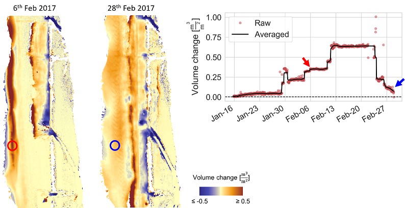
For the larger, six-week period, a volume increase of 0.3 m³/m² is missed on a forming sand bar before it disappears, which corresponds to half its volume. Generally, a strong relationship is shown between observation interval and observed volume change. An increase from weekly to daily observations leads to a five times larger volume change quantified in total.
Another important finding is a temporally variable measurement uncertainty in the 3D time series, which follows the daily course of air temperature.
Will you be there? The research will be presented at the ISPRS Geospatial Week 2019 in the Change Detection session on Wednesday, 12th June 2019, 11:00 am – 12:30 am. The 3DGeo presents another research topic (Kumar et al. 2019) in the Machine & Deep Learning session.
Find all details in the full paper:
Anders, K., Lindenbergh, R. C., Vos, S. E., Mara, H., de Vries, S., and Höfle, B. (2019). HIGH-FREQUENCY 3D GEOMORPHIC OBSERVATION USING HOURLY TERRESTRIAL LASER SCANNING DATA OF A SANDY BEACH, ISPRS Ann. Photogramm. Remote Sens. Spatial Inf. Sci., IV-2/W5, 317-324, DOI: 10.5194/isprs-annals-IV-2-W5-317-2019
The paper is the result of fruitful cooperation within the research projects CoastScan (Dr. Sander Vos, Prof. Roderik Lindenbergh, and Prof. Sierd de Vries) and Auto3Dscapes under lead of Prof. Bernhard Höfle (3DGeo) and Dr. Hubert Mara (FCGL).
An important part of the research was conducted during the research visit of Katharina Anders with the group of Prof. Roderik Lindenbergh in the Geoscience & Remote Sensing department at TU Delft. We thank HGS MathComp for supporting the three-month research visit of PhD student Katharina Anders at TU Delft!

Methods of 4D geospatial data analysis are the core research subject of the Auto3Dscapes project on Autonomous 3D Earth Observation of Dynamic Landscapes. Find out about the 3DGeo group’s work in further geomorphic settings, such as snow cover monitoring at Zugspitze mountain and rock glacier deformation in the Austrian alps.
To stay updated, follow us on ResearchGate!
The PhD project Auto3Dscapes is funded by the Heidelberg Graduate School of Mathematical and Computational Methods for the Sciences (HGS MathComp), founded by DFG grant GSC 220 in the German Universities Excellence Initiative.